Sunday, November 7, 2010

Surfin' Safari

When most Canadians are starting to think about making plans for heading south in the winter, including the Canadian geese whose flying V formations around the city are a reminder that cold weather is on the way, there is one group that shows up every year with the intention of making this spot their winter getaway.  They aren't the Australian youngsters who come to work the ski slopes or the ski tourists themselves, and they aren't refugees either, they are the Surf Scoters, a black and white seaduck with a boldly coloured head that descend on English Bay by the hundreds.  As far as they are concerned, winter conditions here are quite balmy.

Surf Scoter
Content to breed in the freshwater lakes and boreal forests of northern Canada and Alaska in summer, they  make their way to both the east and west coasts for the winter where they make life tough on the mussels, clams, crabs and other invertibrates inhabiting the shallows.  More of a diving bird than a surfing bird, they can dive up to depths of 30 feet in search of food, and they require quite a lot it seems.  In fact it's been estimated that a flock of a thousand Scoters consumes more than 400 pounds of mussel meat a day.


Breeding Area & Migration Routes
Indifferent to human activity along the seawall or out on the water, they go about their business in that strangely collective manner of all birds that congregate in large numbers.  One minute sitting prettily in the water allowing themselves to be photographed, the next minute taking off in a state of chaotic panic, because one of them happened to get spooked by something.  There are so many of them that, by the time the first one touches down again, just a few hundred feet away, most of them haven't even had a chance to react.  It's like a slow motion chain reaction with the whole moving process taking quite awhile to complete.  Of course once they are all settled again it's only a matter of time before everything gets repeated.

Surf Scoters photo by Junie Quiroga
It's quite amusing to watch these characters as they come in to land, with their feet splayed and wings flapping.  Kind of like how I would look if I tried to stand on a surf board, but then again I don't call myself a surfer.  I guess the type of waves they are looking for are the small breaking ones along the shoreline, a surfin' safari that's more about looking for food than riding any waves.

Surf Scoter landing

Friday, November 5, 2010

East of the Sun and West of the Moon

As autumn begins to slowly give way to the end of another year and the days steadily become depressingly shorter, the one bright spot I can always look forward to is the appearance of a certain cluster of stars in the early morning sky. Starting just before midnight and lasting till dawn, the stars that make up Orion's belt and the winter triangle show up like clockwork every year for their seasonal march across the heavens and are probably the easiest stars for any novice stargazer to identify.  Even with all the city lights they are clearly visible.  Of course, depending on what part of the northern hemisphere a person comes from the names will be different but, regardless of the name they are given, the stars never change their pattern.

Orion's Belt
Orion's belt, also known as the Magi, or the Three kings, with its easily identified three stars in a row, forms the middle of the constellation named after Orion the hunter, and serves as the starting reference point for the other winter stars.  Two others which help define the shape of the constellation are the bright star below the belt named Rigel, and the one above named Betelgeuse (Orion's shoulder). Betelgeuse is also the first vertex of the roughly equilateral winter triangle formed with Procyon, to the left and Sirius, the brightest star in the sky, down below.  These late autumn/winter stars; Rigel, Betelgeuse, Procyon and Sirius, are 4 of the brightest 10 objects, as viewed from earth, outside the solar system.

Winter Triangle
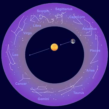
The ancients were fanciful in their imaginings of what the stars represented; lustiness, fairness, warfare, wisdom and who knows what else, never mind how this had something to do with when a person was born. Nonetheless, it continued to occupy a lot of unscientific thinking throughout the ages as various cultures tried to find some sort of correlation between the imagined celestial constellations and the future. Orion tries to remain below the radar of all this nonsense but, if you look a little further above Betelgeuse, you will find the twin stars of Castor and Pollux which form the heads of the Gemini constellation.


Zodiac Constellations

I only mention these distant stars as a way of introducing the role the solar system in general, and the moon in particular, plays in our daily ocean tides; an astronomic phenomenon of which most people are completely unaware. Tides are the rise and fall of sea levels caused by the combined effects of the Earth's rotation and gravitational forces of the sun and moon.  With the moon taking nearly 30 days to orbit the earth this means the tides change approximately 1 hour each day and the rise and fall of these tidal changes depends on where the moon is in relation to the sun.


Tidal Influences

When the Sun and the Moon are aligned, as in the new or full moon phase of each month, the gravitational pull on the earth and its oceans is strongest, producing large tidal bulges (referred to as spring tides) with correspondingly higher and lower tides.  Conversely, when the moon and sun are at right angles to one another in the quarter moon phase, the weaker tidal bulges (called neap tides) produce low tidal change.  In the ocean the tidal range is usually less than 2 feet but, in coastal areas, the tidal range can be anywhere from near zero in the Mediterranean & Caribbean Seas to 53 feet in the Bay of Fundy.  In Vancouver the tidal range is generally around 12 feet. Learning to read and understand local tide charts is indispensable to mariners if they want to avoid accidental grounding or being carried away because they haven't let out enough anchor rode.

Northern Constellations


Of course with the Moon just being something that revolves around the Earth, which in turn revolves around the Sun, a star that revolves around who knows what and fades into insignificance in comparison to most of the others in the Universe, it's hard to put it all into perspective when you are either lying on your back in a field or floating out in the ocean.  But once you can find a star you recognize and determine whether you are either east of the sun or west of the moon you should be okay.


Tuesday, October 26, 2010

Blowing In The Wind

Like pepper is to salt, the wind is to the ocean, a complementary soulmate, lifelong partner and eternal ying to the other's yang.  Shaped by the coastal mountains and Vancouver Island, the prevailing winds add a particular flavour to the Georgia & Juan de Fuca Straits (now referred to as the Salish Sea) that mariners need to play particular attention to if they want to avoid mishap.  There's only one thing that causes waves in the water and that's wind, and the more wind the bigger the waves.


Map of Strait of Georgia

Winds are described by the direction they are coming from, i.e. a northwesterly wind comes from the northwest and, for the most part in this area, the wind patterns are either northwesterlies or southeasterlies.  But, depending on the high low pressure slopes of the wind being funnelled out of the coastal fjords, there are a number of other common wind patterns that can occur, such as the nasty southwesterly called a Qualicum which builds up from Port Alberni Inlet and comes out naturally enough through Qualicum. Another is the Squamish winds, a term for strong, violent outflow winds that are pushed by cold winter air in a northeasterly direction out of the fjords and inlets, particularly in Howe Sound.

Sailing in Georgia Strait/Salish Sea
If you talk to anyone with a sailboat they will tell you the winds are hardly ever going in the right direction as they are either looking for a southeaster when they are heading up the coast a northwester going from Gibsons to Vancouver Island, or a nice westerly from Nanaimo to Vancouver.  But if you want to participate in the bi-annual VanIsle race around Vancouver Island you have to make do with whatever the early summer dishes up and, if that isn't enough, you can get into the winter Polar Bear racing series when the winds are generally a little stronger.

Beaufort Wind Scale

The Beaufort Scale is the standard measurement for describing wind speed and associated wave height and sea conditions on a scale of 1-12 with 1 being calm, flat conditions and 12 being hurricane force winds greater than 118 km/hour with huge waves in excess of 14 metres. Once you get past 6 on the scale things generally start to get a little scary and/or uncomfortable for folks on a small boat, with most people wondering how much longer it will be before they get to a dock.  Anything stronger is only for the foolhardy or extreme sports enthusiasts.

Kite surfing in English Bay


Kite surfing near Squamish

For extreme wind and water sports nothing beats the crazy kite boarding/surfers of English Bay and Squamish who come out in droves when the wind is howling and the waves are pounding the beach. Dressed in wetsuits and strapped into a harness that allows them to hang on to their kite while standing on a board, they use the wind to jump the waves and zoom around the bay at amazing speed.  Blowing in the wind was never so easy.

Sunday, October 17, 2010

There Used To Be A Pier Right Here

English Bay Pier in 1916


One of the greatest mysteries to me is the disappearance of the famous pier that used to exist in English Bay. Built in 1907, the walking/bathing pier was the principal attraction for summer strollers doing their evening promenade and even featured a glassed in dance hall called "The Prom" for fashionable couples to romance the night away.  For over 30 years people enjoyed this delightful extension into the ocean but neglected its upkeep and, on April 17th 1938, it was finally torn down, the same year the Lions Gate Bridge opened.

White Rock Pier
I can understand that wood rots and the pier eventually posed a safety hazard, but why wasn't it ever replaced?  In fact why wasn't an even longer pier built?  Compare the English Bay pier to the one in White Rock which was built around the same time in 1915, and extends 500 metres into Boundary Bay.  The pier is  extremely popular these days with a marina at one end and a concerted effort by the City of White Rock to make it the focal point of a vibrant promenade and beach scene for the public.


Brighton Pier

Whether they are viewed as tacky tourist traps or a unique architectural form that brings land and sea together is a debate more about aesthetics than anything else; a pier being simply a structure built on piles out to the sea from the coastline for use as a landing place or promenade.  It's what people do with a pier that defines its contribution to the surrounding community, and the Brighton Pier is a great example of the English fondness for piers.  The Brighton Pier was one of many constructed in the mid 19th century by English seaside resort towns as a means of attracting passenger steamers.  Elaborate palaces containing theatres, shops and restaurants, they are more popular than ever, in spite of changing tastes in travel, and Britain boasts a National Piers Society that is dedicated to the preservation and enjoyment of its 60 remaining seaside piers.

Eastbourne Pier
The lively west coast piers of California include Santa Monica and Huntington Beach.  Though filled with bars and restaurants, tour boat operators, shops, and amusement parks, they also offer places to fish from or simply relax while surfers and others play in the surrounding ocean. Colourful, lively, and much too energetic for staid Vancouverites who prefer their beaches free from the taint of commercialism.

Santa Monica Pier
Huntington Beach Pier
Even when Vancouver had a pier it seems so quaint in comparison to all these other ones.  A small town on the edge of the rain forest trying to create a miniature of something far away.  Now that we are a big city will we always cede the excitement of the beach scene to suburban White Rock or will we try to enhance our seaside image?  There was a lot more natural purity in 1916 than there is now yet the people still managed to have a pier and dance the night away above the ocean. Now all that remains are a few boulders that show up at low tide to remind us of  "The Prom" that once existed.

Remains of English Bay Pier photo by Junie Quiroga

Wednesday, October 6, 2010

Another Brick In The Seawall


Seawall construction photo by Junie Quiroga

When the fencing went up and the heavy equipment rolled in, it took a few days for the seawall regulars to get over their initial shock and adjust to the temporary detour that had been established for them.  There had been plenty of advance warning signs but, given the usual speed of government bureaucracy, they had never really expected the project to ever get started.  Where were the endless hearings, protests and special interest groups that could usually be counted on to delay things?

Nothing connected to Stanley Park, the most sacred spot in Vancouver, can be done without generating a lot of controversy.  The seawall around the Park is probably its most important feature and most popular facility with cyclists, rollerbladers, joggers and pedestrians using it year round.  Conceived as both a means of controlling the erosion of the foreshore and providing a marine walkway, the seawall was mostly built between 1914 and 1971 and finally finished in 1980.  James Cunningham, a master stonemason, worked on the seawall for 32 years, supervising its construction right up until his death in 1963 and there is a commemorative plaque, near Siwash Rock, where his ashes were scattered, that honours his contribution. 

Stanley Park seawall

But no matter how well it was originally constructed, or how popular it is with the tourists and locals alike, it can't always withstand the forces of nature, particularly in winter when the wind and waves of severe storms hammer it without mercy.  Some areas get hit much worse than others but, when it's the most popular section between 2nd Beach and Sunset Beach, it really gets everyone's attention. The only problem is there's never a good time to do the repairs, especially if they are going to take at least 6 months.  And of course there's always the question of money, in this case $4.5 million.

Stanley Park seawall

No stranger to workfare projects, the seawall used 2,300 unemployed men in the 1920's to complete one of its sections and now 90 years later it was able to take advantage of $2 million in federal workfare money to do some repairs to another section.  However, this being the modern age, there are nearly as many machines as there are workers and the methods are decidedly different.  Within a few weeks the existing wall was ripped out, an access road constructed alongside, and forms were being put in place to start pouring concrete.  This wasn't going to take years of painstaking manual labour to complete.
 
Seawall construction photo by Junie Quiroga
But there's one thing the modern age, or any age for that matter, is not able to have any effect on, and that's the daily tides.  For all their clever techniques the contractor still had to work around the schedule of something bigger than even City Hall.  Every day the low and high tides advance approximately 1 hour, and this meant staggered shifts for the crew in order to take advantage of the low tide when their machines could actually move around and do their work.  While the work area itself was sealed off to pedestrians I was able to track their progress as I went by on my daily morning swim, and I marvelled at how quickly they progressed.

Seawall construction photo by Junie Quiroga
The Stanley Park seawall is actually one section of a 22 kilometer seawall that now starts in Coal Harbour, works its way around Stanley Park, continues into and around False Creek and Granville Island, and then finishes up at Vanier Park.  However, it clearly isn't all built to one standard, and there's a very obvious difference in quality between the public and privately built sections.  In the False Creek and Coal Harbour sections the developers were forced to construct a wider walkway with decorative style paving bricks, provision it with protective railings and put in street lighting.  It's an excellent, first class job that is the envy of the world.  In the publicly constructed sections no improvements whatsoever have been made to the original effort nor are any planned with this latest repair.  The narrow walkways are paved in asphalt, there are no protective railings and there is no lighting.  The stretch in front of English Bay, without a doubt the most heavily used portion, doesn't even have adequate drainage, and everytime it rains (which happens occasionally in this city) the seawall is partially flooded. All in all a shocking disgrace.

Seawall construction photo by Junie Quiroga
Is this something to do with our Canadian psyche that when it comes to spending public money we never want to do anything with proper style or refinement?  Why are we content to settle for mediocrity instead of striving for the best.  Why do the public sections look dingy and drab and the private sections so colourful and inviting?  Just because the seawall is sacred doesn't mean it can't be improved upon and I don't think it would detract from the memory of James Cunningham.  At any rate the orginal granite facing blocks that have been taken off the wall are now for sale if someone wants a souvenir or their own brick from the old wall.
Coal Harbour seawall


Wednesday, September 29, 2010

Where Have All The Cruise Ships Gone?

On October 4th the last Cruise Ship leaves Vancouver for the season.  Fittingly named the Island Princess, either because she cruises islands everywhere she goes or because she is an island all unto herself with all the amenities 1,970 passengers could expect; including a fitness centre/spa, casino and a wide variety of restaurants.  The Island Princess is part of the Princess Cruise line which, in turn, is owned by the Carnival Corporation, the world's largest cruise ship operator, which also owns the Carnival, Holland-America, P&O, and Cunard lines amongst others.  Royal Caribbean is the 2nd largest cruise ship operator but it has the biggest ships with 9 of the top 11 including the very biggest, Oasis of the Seas, which, at 220,000 gross tons, 362 metres in length, and 63 metres in beam, is more than 4 times the size of the Titanic in gross tonnage, 100 meters longer, and twice the width.  It's also capable of carrying over 6,000 passengers and crew, nearly double that of the Titanic. 

Crown Princess photo by Junie Quiroga
For better or worse the Oasis of the Seas has yet to make it to Vancouver but, at a fuel consumption rate of 7,000 gallons per hour at 22 knots, (which works out to 20 gallons per foot) it's probably better off puttering around the Caribbean.  At any rate it wouldn't make it through the Panama canal, where the maximum cruise ship size the locks can accommodate is 290 metres in length and 32 metres in width, so it would be a very long and expensive trip to get here no matter what route it took.  The Island Princess, on the other hand, is part of a class of ships referred to as Panamax, which is the maximum size ships can be to squeeze through the Panama canal.  As a result, they can spend the winter season in the Caribbean and then come up to the Pacific Northwest in summer to cruise the waters of the Inside Passage.

Oasis of the Seas
The seemingly inexhaustable market for folks wanting to check out the beautiful B.C. coastline and the glaciers of Alaska has kept our waterfront humming with the comings and goings of all these massive ships, even with the competition from Seattle.  The 2010 stats aren't out yet but in 2009 there were 35 different vessels here, carrying 900,000 passengers on 256 sailings. The logistics of feeding and watering all these people, never mind the thousands of crew members themselves, is too staggering to contemplate, and let's not forget about the fuel.  And this is only for the Alaska cruise season.  No wonder Micky Arison, the owner of Carnival, is listed by Forbes as the 94th wealthiest person in the world.

 
4 Cruise ships at the Canada Place terminal
While the Island Princess has been busy all summer taking guests back and forth to Alaska, her last cruise of the season is a 17 day re-positioning one to Fort Lauderdale via the Panama Canal.  There she will set up camp for the winter Caribbean season, along with all the other cruise ships in the region who use Fort Lauderdale as their home base.  It's an annual migration that follows the same route as the whales (at least as far as Mexico) and, for those in the know, these re-positioning cruises offer a great bargain.  Next spring, just like the whales, these leviathans of the boating world will return but for now it's goodbye Vancouver.

Wednesday, September 22, 2010

Jelly Jelly

Every year around the end of August and the beginning of September the little aquatic paratroopers start appearing in English Bay.  Acting as the advance party of some secret mission, they quietly sail through the ocean currents, guided by their translucent chutes, towards some mysterious landing spot.  At first they're only a few in number but they are quickly joined by reinforcements and, within a week or so, they are numbering in the thousands.  Suddenly, the invasion is under way and the Bay has been completely taken by surprise.

Moon Jellyfish
Are they really from this planet or could they be friendly extra terrestials?  Are they escaping from somewhere? Is this a way station or the final destination? What is it they have come here for? Is there some special substance in our waters they are wanting to take back with them?  Are they shields for some microscopic creature that will eventually mutate into something completely different?  Can they communicate?

A lot of fantastical questions are created in my mind as I swim through all the little Moon Jellyfish, who are doing their best to ignore me as they go about their business.  I feel their gelatinous bodies bouncing gently and harmlessly off my own and, as I dive under to take a closer look, it seems like I'm in the middle of a strange underwater galaxy.  In actual fact what's happening is a spectacular orgy, and everyone is taking advantage of the perfect water temperature to really get it on before saying goodbye to this life cycle.

Who would have known, but at least they don't bite or sting, unlike another type of jellyfish which also shows up at this time of year, the Lion's Mane.  At an average diameter of 4 - 6 inches the little Moonies aren't even in the same league as the Lion's Mane which are the world's largest jellyfish, growing up to 8 feet in diameter and having a thick array of tentacles, resembling the mane of a lion, that trail up to 90 feet in length, (though the ones I've encountered are generally a third of this size).  They pack an amazingly nasty sting that can leave your arm feeling very sore and painful for hours if you make the mistake of accidentally touching it (which I have) and there are even stories of people dying after being stung.  Even the ends of the tentacles can leave your skin feeling numb if they happen to graze your face or hands.


Lion's Mane Jellyfish

Feeding on zooplankton, small fish, moon jellies and unsuspecting children, the only good thing about the Lion's Mane is they are usually easy to spot and they don't show up in large numbers. Like the Moon jellies they have only a one year life span and, while they spend most of it in the open ocean, they show up in sheltered bays at the end of the year to breed and die.  Their main predators are sea turtles, who like eating jellyfish of any description but must really like their food hot and spicy if they eat these beasties (actually they are immune to the sting).  Unfortunately, sea turtles also get confused by plastic bags that end up in the ocean and try to eat them as well, even if it clogs up their digestive tract and kills them.

With the arrival of the autumn equinox and the end of summer the jellies have suddenly disappeared, and I can swim now without fear of being attacked by a Lion's Mane or being captured by an alien landing party of Moonie sex fiends.  There are over 2,000 species of jellyfish in the world but, thankfully, only a few ever show up here.  Technically they aren't even fish.  Still you have to admire how they get around, and their great sense of rhythm as they pulsate through the water.  Jelly jelly baby.

Friday, September 17, 2010

Sockeye On The Run

The biggest story this past summer has to be about the 35 million Fraser River sockeye salmon that appeared without warning from the depths of the Pacific Ocean, the largest run since 1913.  Even as I was going for my morning swim in English Bay the salmon were jumping out of the water.  Originally presumed missing in action by the Department of Fisheries & Ocean, which has done everything in its power over the years to mismanage fishing stocks on both the Atlantic and Pacific coasts, it was a pleasant surprise for the commercial fishery, the first nations, and the general public to suddenly have all this wonderful fish available.  Sockeye, of course, being the most prized of the 5 indigenous salmon species (Coho, Pink, Chinook, & Chum being the others) due to its rich flavour and firm, deep red flesh.

Granville Island Salmon photo by Junie Quiroga

Like all salmon, the sockeye have a well established fresh water/salt water life cycle that starts with the eggs hatching in some fresh water stream, the juvenile smolts eventually making their way to the open ocean to feed and grow and then return, as mature adults 4 years later, to spawn in the exact same spot where they were born, before dying.  In the case of sockeye this cyclical migration can be thousands of miles from spawning grounds to feeding grounds and, how they find their way back and forth, is probably one of nature's most enduring mysteries. Some annual cycles are larger than others however, with 2010 being part of the most dominant 4 year cycle for the Fraser River, the largest salmon river in the world.  In 2006 this same cycle saw 13 million sockeye return to the Fraser River, but there is a big difference between 35 million and 13 million and an even bigger difference when one considers the less than 1.5 million sockeye that returned last year.

Salmon migration routes
When the less than 1.5 million salmon returned last year alarm bells immediately started ringing.  Overfishing, sea lice, too many marine mammals, and climate change were cited as the most likely culprits and many declared the sockeye was on the verge of being wiped out. But if that was the case how do you explain all the fish this year?  In the world of fish it's either eat or be eaten.  An estimated 10 billion salmon smolts of all species enter the Gulf of Alaska every year and, while they suffer a heavy mortality rate, the millions that survive the gauntlet of predators is truly astounding.

During their time in the ocean sockeye salmon feed off plankton and tiny shrimp.  If climate change had affected the ocean it must have led to more plankton and shrimp being produced because obviously the sockeye had no shortage of food. Alternatively the predators that eat salmon might have disappeared but it would appear the seals, sea lions and orca whale populations are all on the increase so that isn't the answer either. It's also unlikely the sockeye have developed an immunity to sea lice, considering they have been around for as long as the salmon themselves so, as nasty as they are, the speculation over sea lice from fish farms doesn't really seem to have any substance.  And with the annual fishing quota being steadily reduced it doesn't seem like overfishing was the culprit this time.  More questions than answers.

Granville Island Salmon photo by Junie Quiroga
It all goes back to what happens during that 2 year period the sockeye are in the ocean with no babysitters, GPS tracking sytems, or video cameras watching their every move.  Teenage wildlife with no responsibilities or restrictions.  An all too brief time to bond with friends, eat and drink to their hearts content, and travel wherever the current leads them.  What goes on the road stays on the road and the kids aren't talking. 
   
But what to do with all these fish?  It seems like feast or famine.  Normally selling for anywhere between $10.00-$20.00/lb in the market, now whole sockeye were being sold for $20.00 or less right off the boats.  With hardly any canneries even operating anymore everyone was scambling to find a way to unload the catch and restaurants everywhere had salmon specials on the menu.  But all of this is only affects a fraction of the fish, with the majority being left alone to try and spawn.  Critics are now saying the spawning channels are overcrowded and most of the fish will simply die, a colossal waste of fish.


It wasn't always that way.  In the late 1800's the canning industry came to the Fraser River.  Perfect timing as it turned out with a unique combination of events.  The fur trading posts at Prince Rupert and Fort Langley were closing down just as canneries were being established to replace the previous method of packaging fish by simply salting the salmon in barrels.  With the great CPR railway construction project completed there was lots of surplus labour, mostly Chinese, to work in these very labour intensive factories.  In 1871 the canning industry was launched by Alexander Ewen with 2,000 salmon hand filled into 300 cases of hand soldered cans.  By 1880 42,000 cases were filled and 126,000 cases the next year.  The race was on.

Canneries started proliferating and soon there were nearly 100 canneries between the Fraser and Skeena Rivers. With the seemingly endless supply of fish in B.C. it was a license to print money but, over the next 100 years, the industry would be in constant conflict with competing claims for the fish by Natives and  fishermen, labour disputes for better working conditions and wages at the canneries and racist government policy towards the Chinese and Japanese that culminated in the confiscation of Japanese fishing boats during the Second World War Internment. 


Confiscated Japanese fishing vessels
From the beginning it was evident the amount of fish being harvested was unsustainable but, instead of practising conservation or some form of restraint, the industry simply went after other fish including the other salmon species as well as herring and halibut.  Almost exactly 100 years from when the salmon fishing industry got started, it collapsed.  Canneries were amalgamated and closed, fishing vessels were mothballed, their licenses sold back to the government, and the farming of Atlantic salmon took over. 

For the sockeye, however, it wasn't the fishing industry that had the biggest impact.  In August 1913 blasting by the CNR caused a landslide at Hells Gate in the Fraser River that destroyed one of the largest ever salmon runs trying to make its way upstream.  Millions of fish died before getting to their spawing grounds and, by 1921, two cycles later, the sockeye industry was dead.  It would take another 100 years to recover.

Hells Gate before the landslide
 
Hells Gate after the landslide
  
Hells Gate today with fish ladders
So now its August 2010, the sockey are back and we are hopeful that the last 140 years of greed, mismanagement, and folly can somehow be repaired.  That a species with a history probably older than ours can get back to its routine again in spite of everything we've done to disrupt it.  The arrogance of thinking we can "manage" something we know so little about is almost more astounding than the 35 million sockeye who appeared this summer out of nowhere.  But it's a great year in the spawning grounds and, at least for today, there's plenty to spare for us to eat as well.  It could always be that way if we are just a little more careful.

Wednesday, September 15, 2010

A Whale With No Name

Over the Labour Day weekend someone had made a whale sand sculpture on the beach at English Bay.  A tribute no doubt to the grey whale that has been delighting everyone with his sporadic guest appearances throughout the summer.  I say "he" because in the whale world it's generally the women and children that stick together and only the males who go walkabout on their own.

Whale Sand Sculpture photo by Junie Quiroga

Of course the whale didn't have any papers to show either the Fish & Wildlife, Coast Guard, or Customs & Immigration officials that would normally be controlling the access of pelagic tourists choosing to enter Vancouver by sea, so nobody really knows anything about him including his name. He first showed up in May coming into False Creek and doing a bit of an O.J. Simpson with helicopters circling around him and everyone crowding the bridges and seawall to get a glimpse and take photos.  He also took his tour to the bustling metropolis of Squamish to wow the locals there and then spent the summer cruising along the Sunshine Coast and mingling with the boaters before coming back to Vancouver.


photo by Andrew Hood
While hunted to extinction by the 19th century on the east coast of North America, grey whales survived on the west coast and, in the 20th century were only hunted sporadically.  The last grey whale hunting in B.C. was in 1953 when a dozen were killed, and in California a few hundred were killed in the 1960's.  Since then they have been protected from commercial fishing (in spite of the Makah tribe in Washington state who are still claiming the right to hunt a few every year) and their population has grown to over 20,000 individuals.
Grey Whale and her calf


Migrating up and down the coast from the warm winter waters of Baja, Mexico, where they mate and give birth, to the cool waters of British Columbia and Alaska in summer, where they come to feast, their aquatic world knows no borders.  All they are interested in are the yummy amphipods and benthic crustaceans they scoop up along with all the mud, sand and sediment on the ocean bottom, that they mix together with a generous amount of seawater, and then strain it all through their baleen, a sort of natural sieve that is built into their mouth. It's a healthy diet that allows them to grow up to 50 feet in length, 35 tons in weight, and live until the ripe old age of 60 years.

English Bay Slide photo by Junie Quiroga


Watching that September afternoon as the whale cruised along the stretch of beach between English Bay and Second Beach, where I go for my daily morning swim, I decided to put on my wetsuit and join him.  Unfortunately for me, by the time I got past all the excited sunbathers, the whale had already headed over to Kits Beach and into the ocean.  Considering grey whales cruise at 8 km per hour compared to my 2 - 3 km per hour (depending on current) I didn't have a hope of catching up.

As I watched him disappear into the sunset of his borderless world I couldn't help but envy his lifestyle and was glad to see he had such a huge fan club.  Perhaps he will spread the word to the others that it's safe to come through the Inside Passage again and the scenery is just as interesting as on the West Coast.  Maybe I'll even meet up with him down in Mexico one winter.

Friday, September 10, 2010

Over, Under, Sideways, Around

In the year 2000 I started swimming in the ocean.  It was all part of training for a millenium project, the Alcatraz Swim, that I had started with some fellow pool rats in the Vancouver Aquatic Centre, and it was to have a profound effect on my lifestyle, how I viewed the city I'd grown up in, and my view of nature.  There was another world out there I'd never really given much thought to and it had been on my doorstep all along.

Swims With Seals photo by Junie Quiroga

Even though I lived within a block from the ocean and was born and raised in Vancouver, it had never occurred to me to swim in the ocean. Other than taking an occasional dip in the summer, serious swimming was done in swimming pools.  To be fair, most of the year the water was cold and so was the air but, if we could put men on the moon, these were minor inconveniences a little technology should easily resolve. In this case all it took was a stretchy neoprene suit with matching boots, gloves and hood.


Nelson & Jack photo by Junie Quiroga

Out in the fresh air and away from the usual "smell of chlorine first thing in the morning" this invigorating new environment was already quite a shock to the system but, when the seals showed up to accompany me, things started to get magical.  Curious, friendly but also a little shy, the seals seemed to guide me and keep an eye out for boat traffic, as I swam from Kits to Second Beach, and probably wondered what had possessed me to swim here in the first place. I'd been counting laps in pools for longer than I cared to remember and, as much as I'd always enjoyed it, I realized now there was no going back to an artificial environment.

Crown Jewel photo by Junie Quiroga

I was now one with the ocean and the seals every morning when I went for my swim, and it didn't take long from there before I had purchased a cabin cruiser to start exploring the surrounding waters.  With a boat and an obsession for swimming in the ocean the final logical step was to take up scuba diving, and soon I also became a Divemaster.  The more time I spent either over, under, sideways and around the water the more I realized how much was going on and how unaware most people were of all the ocean happenings.

Nelson Quiroga photo by Junie Quiroga

Whether it's about the commercial side of things with the shipping, tugs and fishing boats, the recreational activities such as rowing, kayaking, windsurfing, paddling, and sailing, all the creatures living in the water or all the clubs and organizations dedicated to supporting and/or protecting these things, never mind all the history, the ocean has more of an impact on the city than I think anyone really stops to think about.  But where is the collective voice for all these interests? Perhaps there isn't such a thing but, after 10 years of developing and qualifying my own unique perspective, I feel it's time to start sharing my thoughts about the ocean scene in the Vancouver area.