Sunday, May 29, 2011

Row Row Row Your Boat

Rowing has a long and respected history in Vancouver, with the Vancouver Rowing Club itself founded in 1886, the same year as the City, and both entities celebrating their 125th birthday this year.  Pleasantly situated at the entrance to Stanley Park and at the end of Coal Harbour, experienced and novice beginners alike can be seen most afternoons as they carefully and methodically scull (2 oars) or sweep (1 oar) in perfect synchronization either singly, in pairs, fours or eights. The club has produced its share of Commonwealth and Olympic medal winners over the years, and there always seems to be a fresh batch of recruits eager to learn the technique and get some serious exercise in the process.

Vancouver Rowing Club photo by Junie Quiroga
Rowing seems to lend itself readily to racing and, while the actual history of the sport is a little sketchy, we do know the first Oxford Cambridge race took place in 1829 and since then the rivalry between countries, colleges and clubs has never let up.  In the lower mainland alone there are more than 17 official rowing clubs.  While owing to all the boat and airplane traffic the practice area of the Vancouver Rowing Club isn't a practical location for regattas, there's one taking place nearly every weekend somewhere else.


It's not just humans who are fascinated with rowing either.  If you look closely from the seawall you will often see one of the local seals keeping an eye on the rowers.  One seal in particular has been given the name of "coach" because of its habit of popping up around the rowers and seeming to offer advice.  And while I'm swimming in English Bay I often encounter another group of rowers, the False Creek Rowing Club, and their mascot "Ellie" a dog who rides around in the coach's dinghy keeping an eye on things and generally having a great time skimming over the water.


But rowers are only one group of human powered boaters racing in the Vancouver waters, with the paddling community being perhaps the most visible, particularly the Dragon Boaters. Dragon Boat racing has a much more ancient history than rowing, going back 2,000 years in China but was only introduced to Vancouver at the 1986 Expo. Since then it has exploded in popularity with the annual Dragon Boat festival now drawing nearly 200 teams worldwide to compete in a colourful, multicultural event with thousands of spectators ringing the shores of False Creek.


The obvious difference between the rowers and the paddlers is that one group is facing forward and the other is facing backwards as they ply their oars.  As to which method is faster it's hard to say.  A quick review of the Olympic records for paddling a kayak or canoe on a 1,000 metre course is somewhere between 3.5 - 4.0 minutes but, on a 2,000 metre rowing course the times are between 5.5. - 6.5 minutes.


It's a bit like comparing apples to oranges but suffice it to say either method is right up there with the 1,500 metre run which has an Olympic record of approximately 3.5 minutes. Why anyone would need to row or paddle that fast is beyond me unless of course they were being chased by something.

Monday, March 21, 2011

If You're Going To The North Country part 1

In a quiet little corner of Kitsilano sits the Vancouver Maritime Museum, a building overflowing with its collections and artifacts of maritime history and home to the famous R.C.M.P. vessel the St. Roch.  The St. Roch being the first vessel to sail the Northwest Passage from West to East (1940 - 1942) the first vessel to cruise the Northwest Passage in both directions (when it completed an East West journey two years later in a single season) and the first vessel to circumnavigate North America.  Built out of wood and powered by a single 150 hp diesel engine the patrol vessel was originally built in 1928 and stayed in service until 1950.

St. Roch


That the ship would make its final home in Vancouver (where it was originally built) is perhaps more appropriate than most people would realize.  Vancouver after all was named after the famous sea captain who spent 3 seasons from 1792 to 1794 on the HMS Discovery exploring and surveying the rugged B.C. coastline all the way to Alaska in a fruitless search for the Northwest Passage. Each new fjord Vancouver encountered seemed to offer a connecting passage to the North but, as he sailed into them, meticulously mapping every detail along they way, each waterway would prove to be a dead end.

HMS Discovery


Interestingly, these two ships were roughly the same size, Discovery being 99 feet long with a beam of 28 feet and St. Roch being 104 feet long with a 24 foot beam.  But the first ship to complete the Northwest Passage was the Gjoa, in 1906, following an East West route that had taken three winters to complete.  A 70 foot herring fishing boat originally built in 1872, it was converted into a motor-sailor vessel with the addition of a 13 hp motor. The Captain was Roald Amundsen, a Norwegian.  It was another Norwegian, Henry Larsen, who captained the St. Roch, though he had already become a Canadian citizen in 1924.

Gjoa
The fabled Northwest Passage was something people had been seeking since John Cabot tried in 1496 and it wasn't until 1854 that it was proved a route even existed. Robert McClure had been leading an expedition to search for the lost and disastrous Franklin expedition of 1848, when his ship got caught in the ice of Prince of Wales Strait between Banks and Victoria Islands as he was trying for a West East route.  Carrying on by sledge he then discovered Barrow's Strait and the connecting passage, which won him the prize of 10,000 English pounds for finding the route.

Northwest Passage
Various routes of the Northwest Passage

  1. TYPICAL NORTHWEST PASSAGE ROUTE (Black)    MORE...
  2. ROALD AMUNDSEN: First Navigation by Ship (White)    MORE...
  3. ST. ROCH: First West-East Crossing (Green)    MORE...
  4. ST. ROCH: Northern Deep-Water Route (Yellow)    MORE...
  5. FRANKLIN EXPEDITION: Attempt (Dark Red)    MORE...
  6. SIR WILLIAM EDWARD PARRY: Attempt (Purple)    MORE...
  7. ROBERT McCLURE: Proved route existed (Orange)    MORE...

A Northwest Passage has always offered the promise of a quicker route between Europe and Asia but the short window of time available for the journey, before the seas freeze over, has made it an impractical proposition.  Even when the supertanker Manhattan completed the voyage in 1969 with the aid of a Canadian icebreaker it still wasn't considered cost effective.  However, with recent climate changes that appear to be melting some of the polar ice, interest has again surfaced in making the Northwest Passage a viable commercial route and, in 2009, two cruise ships completed the passage.

Nadon
An ice free Northwest Passage brings with it all sorts of issues around sovereignty and protection which is now being debated amongst all the countries bordering the North Pole area.  Canada naturally takes the position these waters are all internal and within her jurisdiction while others see this as an international strait.  As a result deep water ports are being built and the Coast Guard is stepping up patrols and presence in the area.  One of the recent cruises to raise awareness of the Northwest Passage was the modern R.C.M.P. patrol vessel the Nadon which, in 1999 - 2000, recreated the famous West East route of the St. Roch.  The Nadon is based in the waterways of Vancouver and one of the main purposes of the voyage was to raise funds for the preservation of the St. Roch.

Sunday, February 20, 2011

Sitting On The Dock Of The Bay

Looking out at English Bay one of the first things anyone would notice are the freighter ships.  There could be up to 15 at anchor at any one time (because that's how many designated spots have been marked on the chart for them to use) or there could just be one or two, but they're always out there quietly floating about, changing direction with the tides, and minding their own business. Very seldom are there any signs of life though occasionally you may also see a Customs boat tied up alongside, presumably giving the crew the same runaround they give everyone else at the border. 

English Bay Freighters photos by Junie Quiroga

From time to time one of their bright orange life boats are launched into the water and, assuming everyone inside survived the dunking, they can be seen speeding to shore to stock up on whatever provisions our fair city has to offer.

Lifeboat
Unlike the container ships which come speeding into port and are immediately tied up at a dock for loading and unloading, the general cargo and bulk carriers seem content to meander in and patiently wait their turn.  What they are waiting for depends, of course, on what type of ship they are and what it is they are either dropping off or picking up.

The Port Authority chart below helps identify the various types of ships that come into Vancouver.  The typical turnaround time for a container ship is 12 hours and 15 hours for an automobile ship.  However the typical turnaround time for bulk carriers is at least 74 hours with unloading taking twice as long as loading.  The good news for crew members on bulk carriers is they have more opportunities to spend time ashore.


It's hard to appreciate how large these ships are unless you can get up close somehow to try and get some perspective.  Even then the reality of a ship carrying between 5,000 - 15,000 containers (which would equal a line of 5,000 - 15,000 highway trucks) is pretty overwhelming yet that's exactly what the current class of container ships is capable of handling.  The newest designs are allowing for 18,000 containers.  Last year over 2.5 million of these containers were loaded and unloaded at the various container docks in Vancouver.

Container ship

Equally impressive are the new car RORO carrier ships (Roll On Roll Off) which can carry more than 6,000 automobiles in their specially designed holds.  While these box like ships provide complete protection for their cargo they also have a reputation for being a high risk design because if the holds are not properly secured water can get in and either sink or destabilize the ship.  On the other hand the very high enclosed decks also make it virtually impossible for water to get inside. Last year 382,000 cars made it safely to Vancouver.

RORO carrier ship


There are 4 main categories of bulk carriers, Handysize and Handymax which make up 71% of all bulk carriers with Handymax carriers typically 150 - 200 metres in length, capable of carrying between 50,000 - 59,000 DWT (dead weight tons) and having five cargo holds and four cranes.  Panamax ships handle between 60,000 - 80,000 DWT but are limited by the size of the Panama canal to being only 32 metres wide and 294 metres in length. Capesize ships have a capacity in excess of 80,000 DWT but, because they are so large, they must go around either the Cape of Good Hope or Cape Horn to travel between the oceans. Last year 80 million tons of bulk goods moved through the Port of Vancouver reflecting the insatiable demand for goods between Asia and North America.


Bulk Freighter
 The greatest hazard of bulk freighters is the continuous danger of "breaking their backs" and thus longitudinal strength is the principal architectural concern. Stresses put on the ship when it is being loaded or unloaded, cargo shifting at sea, and water getting into the hatches, can all cause a ship to break in half and sink. Corrosion is another huge contributing factor. The 1990's was a very unsafe time for bulk carriers with 99 lost between 1990 - 1997.  Most of the sinkings were sudden and quick making it impossible for the crew to escape and more than 650 sailors were lost during this period.  Since then a number of international safety regulations and design changes have come into effect.


Free fall lifeboats mounted on the stern are now mandatory for all Panamax and Capesize freighters, though there is still the hazard of riding one of these into the ocean if your seat belt isn't on properly. Double hulls, reinforcing the bulkheads and longitudinal frame, more inspections with a particular focus on corrosion and better loading procedures have all been put into place, but a large number of ships continues to be lost every year, with weather the main culprit.

Rough Seas

The bigger they are the harder they fall and when you are dealing with ships it doesn't get any bigger or more spectacular.  The amount of cargo lost and the cost is staggering, never mind the hazard to the environment if something toxic leaks into the ocean. The spectre of another Exxon Valdez 11 million gallon oil spill is something that has now entered the debate over the oil tankers quietly operating out of Vancouver.

Mazda Ship
MSC Chitra


Exxon Valdez

So next time you see one of those mighty freighters quietly sitting at anchor, and wonder where what they're up to, think for a moment about how fragile they really are and the fact there probably isn't anything nicer for a sailor to be doing than sitting in English Bay.


Tuesday, December 28, 2010

Gasoline Alley

Once upon a time if you looked into Coal Harbour, so named because of the low grade coal seams (first spotted by Captain Vancouver) that were visible along the banks of what is now Hastings Street, you would see at least 3 floating marine fuel stations tethered to their pilings, bright signage clearly on display, and cheerfully promoting the Chevron, Esso and Shell oil brand names.  While coal may continue to be the principle source of fuel for generating the world's electricity and heat, the world's transportation industry still depends on various petroleum products to power its trains, planes, automobiles and ships.  And with Vancouver being a port city it seemed to make sense that a water based system of refueling would be available to both commercial ships and recreational boaters.

Chevron & Esso fuel barges

Since the 1960's there seemed to have been a vibrant, competitive business going on until Shell dropped out and it was just Esso and Chevron.  Then in the summer of 2008 Esso announced it was getting out of the marine fuel business completely and was shutting down all of its stations along the coast including the floating one in Coal Harbour and another one in False Creek.  In spite of an ever growing number of pleasure boaters, fuel sales continue to drop and they claimed there just wasn't enough profit in the business anymore.  Hard to believe when I happen to own a power boat myself and nearly have a heart attack everytime I have to fill up thanks to my 2 miles per gallon fuel economy, and that's only doing 10 knots.  If I went any faster it would be even worse, but I guess that's exactly the point.  With the price of fuel continuing to rise power boaters are just not out there cruising like they used to, and most of the boats are staying tied up at the dock.

Futuristic design for a solar powered  bulk carrier
Unfortunately boats aren't very fuel efficient inventions, at least at first blush when you think about a freighter getting only 23 feet to the gallon.  But when you factor in how much cargo one of these ships can carry as compared to say an equivalent number of trucks or railcars, then the math gets much more interesting with ships twice as efficient as trains and 10 times more efficient than trucks.  However, a typical bulk carrier still goes through approximately 9,000 gallons of fuel a day so, regardless of how efficient these freighters are, you can understand why designers would want to experiment with things like solar power and other ways of reducing fuel consumption. Unfortunately none of this matters to the floating fuel stations because, while they would like to fill up the tank of a freighter, these ships only burn bunker oil, not gas or diesel, so they're out of luck. Ditto for the cruiseships. 

Futuristic design for a solar powered carrier
Another problem facing floating marine fuel stations of course is the ever changing environmental concerns and safety requirements.  Keeping an operating permit depends on all sorts of inspections and compliancy with various levels of government.  In January 2010 a brand new, state of the art, double hulled fuel barge with special design features to contain any rain water and oil contamination, was towed into Coal Harbour and set up to replace the old one that had been in place since 1959.  With storage capacity for 42,000 gallons of gas and 339,000 gallons of diesel, local pleasure boaters can be assured of a reliable supply of fuel for the forseeable future.

Chevron Fuel Barge photo by Junie Quiroga
But it's not the pleasure boaters this new fuel station is catering to, it's the tug boats.  Even the smallest one has a 50,000 gallon tank and the big one featured at the back of the barge in the picture above has a 225,000 gallon tank.  With the maximum output of the pumps around 13,000 gallons an hour it can take a deckhand an entire 8 hour shift to fuel up and that's only if the tank is half empty.  I guess I shouldn't feel so bad about the fuel I burn in comparison.  Gasoline alley may be down to just one operator now but it still moves more petroleum based fuel than any of the wildest estimates anyone ever expected when they first discovered coal.

Tuesday, December 7, 2010

Will I See You In December?

Swimming in the ocean every morning is always a different experience, and whether it's the tides and current, the weather, or the creatures I encounter, no two days are ever the same.  I have never kept track of every beautiful sunrise or calm ocean swim but I have tried to track every day I've had an encounter with a seal and, over the years, this has yielded a fairly consistent pattern.  I say try because, while seals appear to be curious and usually make themselves visible, they are also cautious and can be deliberately shy or coy about their presence.

Harbour Seal
While there are 19 different species of seals within the family Phocidae, also referred to as "true seals" or "earless seals" the one most common to the Vancouver area is the Harbour seal.  Generally staying within a 20 kilometer range, they're an easy going non-territorial bunch, appearing to share haulout spots, foraging for fish and crustaceans in a common area, and even swapping mates amongst themselves from one year to the next.  Pups are born from between June and September, followed by everyone having their annual moulting, and then in late fall it's back to mating season. 

This all ties in quite nicely with my own logbook, which shows the seals are less likely to make contact in the summer, when presumably they are off having their babies and suntanning in more protected locations, and then returning in December to check out the mating action.  Sometimes it even seems I'm being considered as a potential candidate because they come very close by, often swimming right underneath me, while batting their eyelashes and making splashes.  Only trouble is I don't know if they think I'm male or female, and I can't really tell what they are either.

Stellar Sea Lions
The seal superfamily known as Pinnipedia contains 3 distinct groups of sea mammals.  The Phocidae already mentioned, the Odobenidae otherwise known as the walrus, and the Otariidae or "eared seals" which are the sea lions. Of the 16 different species, the California sea lion and the Stellar sea lion are the ones found cruising our local waters.  Besides the fact that one group has ears and the other doesn't, there are some other striking differences that make it easy to tell the difference between seals and sea lions.

The most obvious difference of course is size, with the Harbour seals weighing in at between 120-370 pounds and the Stellar sea lions between 1300-2500 pounds.  On the other hand a male Elephant seal can easily get up to 5,000 pounds (even though the females are only around 1,400 pounds) so seals can be just as big.  But the most distinguishing feature is their flippers.  The two back flippers on a seal form a tail like structure that aids them in being very efficient in water but very awkward on land and their front flippers are quite small.  The sea lion on the other hand has very large, powerful front flippers, that are its primary source of propulsion, and its rear flippers can turn forward so it can move on all fours quite easily on land.


There is another big difference between the Harbour seals and the Stellar or California sea lions and that is the distance they will go to forage for food.  Harbour seals live in the same place year round taking advantage of whatever seasonally abundant prey happens to be in the neighbourhood while sea lions are quite prepared to go on long swim-abouts if the eating is good.  So every winter, when the Pacific Herring make their way to selected spawing locations on the West Coast, the sea lions are waiting for them at haulouts along the way. 

One of these haulouts is just off Hornby Island where, starting in December, the males from California head north and the Stellar males from Alaska head south, (leaving the women and children behind at the home rookeries) to congregate for a big bachelor party and herring feast.  This is a popular spot for scuba divers to interact with these friendly beasts, who act like playful dogs, and want nothing more than a little diversion, while they wait for the herring to arrive.  Occasionally these sea lions take a detour to check out the sights and sounds around the Vancouver area as well and last weekend I found myself playing with one on a dive off Whytecliff Park.   

Sea Lions & Nelson at Hornby Island

And that's another difference between seals and sea lions.  Seals will come up close to check you out whether you are swimming or scuba diving but they won't play or interact on anything close to the level of a sea lion.  It's said that sea lions have the intelligence of a dolphin and it appears they can be quite easily trained to do a variety of tasks that range from performances in public Aquariums to guard duty at Naval stations.

Nonetheless, between the seals showing up for the start of mating season and the sea lions getting ready for their annual bachelor party I always look forward to seeing my aquatic companions in December and every encounter is always special.

Sunday, November 7, 2010

Surfin' Safari

When most Canadians are starting to think about making plans for heading south in the winter, including the Canadian geese whose flying V formations around the city are a reminder that cold weather is on the way, there is one group that shows up every year with the intention of making this spot their winter getaway.  They aren't the Australian youngsters who come to work the ski slopes or the ski tourists themselves, and they aren't refugees either, they are the Surf Scoters, a black and white seaduck with a boldly coloured head that descend on English Bay by the hundreds.  As far as they are concerned, winter conditions here are quite balmy.

Surf Scoter
Content to breed in the freshwater lakes and boreal forests of northern Canada and Alaska in summer, they  make their way to both the east and west coasts for the winter where they make life tough on the mussels, clams, crabs and other invertibrates inhabiting the shallows.  More of a diving bird than a surfing bird, they can dive up to depths of 30 feet in search of food, and they require quite a lot it seems.  In fact it's been estimated that a flock of a thousand Scoters consumes more than 400 pounds of mussel meat a day.


Breeding Area & Migration Routes
Indifferent to human activity along the seawall or out on the water, they go about their business in that strangely collective manner of all birds that congregate in large numbers.  One minute sitting prettily in the water allowing themselves to be photographed, the next minute taking off in a state of chaotic panic, because one of them happened to get spooked by something.  There are so many of them that, by the time the first one touches down again, just a few hundred feet away, most of them haven't even had a chance to react.  It's like a slow motion chain reaction with the whole moving process taking quite awhile to complete.  Of course once they are all settled again it's only a matter of time before everything gets repeated.

Surf Scoters photo by Junie Quiroga
It's quite amusing to watch these characters as they come in to land, with their feet splayed and wings flapping.  Kind of like how I would look if I tried to stand on a surf board, but then again I don't call myself a surfer.  I guess the type of waves they are looking for are the small breaking ones along the shoreline, a surfin' safari that's more about looking for food than riding any waves.

Surf Scoter landing

Friday, November 5, 2010

East of the Sun and West of the Moon

As autumn begins to slowly give way to the end of another year and the days steadily become depressingly shorter, the one bright spot I can always look forward to is the appearance of a certain cluster of stars in the early morning sky. Starting just before midnight and lasting till dawn, the stars that make up Orion's belt and the winter triangle show up like clockwork every year for their seasonal march across the heavens and are probably the easiest stars for any novice stargazer to identify.  Even with all the city lights they are clearly visible.  Of course, depending on what part of the northern hemisphere a person comes from the names will be different but, regardless of the name they are given, the stars never change their pattern.

Orion's Belt
Orion's belt, also known as the Magi, or the Three kings, with its easily identified three stars in a row, forms the middle of the constellation named after Orion the hunter, and serves as the starting reference point for the other winter stars.  Two others which help define the shape of the constellation are the bright star below the belt named Rigel, and the one above named Betelgeuse (Orion's shoulder). Betelgeuse is also the first vertex of the roughly equilateral winter triangle formed with Procyon, to the left and Sirius, the brightest star in the sky, down below.  These late autumn/winter stars; Rigel, Betelgeuse, Procyon and Sirius, are 4 of the brightest 10 objects, as viewed from earth, outside the solar system.

Winter Triangle
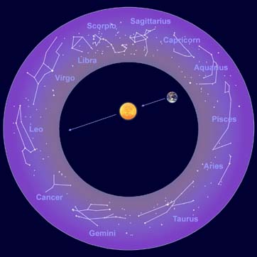
The ancients were fanciful in their imaginings of what the stars represented; lustiness, fairness, warfare, wisdom and who knows what else, never mind how this had something to do with when a person was born. Nonetheless, it continued to occupy a lot of unscientific thinking throughout the ages as various cultures tried to find some sort of correlation between the imagined celestial constellations and the future. Orion tries to remain below the radar of all this nonsense but, if you look a little further above Betelgeuse, you will find the twin stars of Castor and Pollux which form the heads of the Gemini constellation.


Zodiac Constellations

I only mention these distant stars as a way of introducing the role the solar system in general, and the moon in particular, plays in our daily ocean tides; an astronomic phenomenon of which most people are completely unaware. Tides are the rise and fall of sea levels caused by the combined effects of the Earth's rotation and gravitational forces of the sun and moon.  With the moon taking nearly 30 days to orbit the earth this means the tides change approximately 1 hour each day and the rise and fall of these tidal changes depends on where the moon is in relation to the sun.


Tidal Influences

When the Sun and the Moon are aligned, as in the new or full moon phase of each month, the gravitational pull on the earth and its oceans is strongest, producing large tidal bulges (referred to as spring tides) with correspondingly higher and lower tides.  Conversely, when the moon and sun are at right angles to one another in the quarter moon phase, the weaker tidal bulges (called neap tides) produce low tidal change.  In the ocean the tidal range is usually less than 2 feet but, in coastal areas, the tidal range can be anywhere from near zero in the Mediterranean & Caribbean Seas to 53 feet in the Bay of Fundy.  In Vancouver the tidal range is generally around 12 feet. Learning to read and understand local tide charts is indispensable to mariners if they want to avoid accidental grounding or being carried away because they haven't let out enough anchor rode.

Northern Constellations


Of course with the Moon just being something that revolves around the Earth, which in turn revolves around the Sun, a star that revolves around who knows what and fades into insignificance in comparison to most of the others in the Universe, it's hard to put it all into perspective when you are either lying on your back in a field or floating out in the ocean.  But once you can find a star you recognize and determine whether you are either east of the sun or west of the moon you should be okay.


Tuesday, October 26, 2010

Blowing In The Wind

Like pepper is to salt, the wind is to the ocean, a complementary soulmate, lifelong partner and eternal ying to the other's yang.  Shaped by the coastal mountains and Vancouver Island, the prevailing winds add a particular flavour to the Georgia & Juan de Fuca Straits (now referred to as the Salish Sea) that mariners need to play particular attention to if they want to avoid mishap.  There's only one thing that causes waves in the water and that's wind, and the more wind the bigger the waves.


Map of Strait of Georgia

Winds are described by the direction they are coming from, i.e. a northwesterly wind comes from the northwest and, for the most part in this area, the wind patterns are either northwesterlies or southeasterlies.  But, depending on the high low pressure slopes of the wind being funnelled out of the coastal fjords, there are a number of other common wind patterns that can occur, such as the nasty southwesterly called a Qualicum which builds up from Port Alberni Inlet and comes out naturally enough through Qualicum. Another is the Squamish winds, a term for strong, violent outflow winds that are pushed by cold winter air in a northeasterly direction out of the fjords and inlets, particularly in Howe Sound.

Sailing in Georgia Strait/Salish Sea
If you talk to anyone with a sailboat they will tell you the winds are hardly ever going in the right direction as they are either looking for a southeaster when they are heading up the coast a northwester going from Gibsons to Vancouver Island, or a nice westerly from Nanaimo to Vancouver.  But if you want to participate in the bi-annual VanIsle race around Vancouver Island you have to make do with whatever the early summer dishes up and, if that isn't enough, you can get into the winter Polar Bear racing series when the winds are generally a little stronger.

Beaufort Wind Scale

The Beaufort Scale is the standard measurement for describing wind speed and associated wave height and sea conditions on a scale of 1-12 with 1 being calm, flat conditions and 12 being hurricane force winds greater than 118 km/hour with huge waves in excess of 14 metres. Once you get past 6 on the scale things generally start to get a little scary and/or uncomfortable for folks on a small boat, with most people wondering how much longer it will be before they get to a dock.  Anything stronger is only for the foolhardy or extreme sports enthusiasts.

Kite surfing in English Bay


Kite surfing near Squamish

For extreme wind and water sports nothing beats the crazy kite boarding/surfers of English Bay and Squamish who come out in droves when the wind is howling and the waves are pounding the beach. Dressed in wetsuits and strapped into a harness that allows them to hang on to their kite while standing on a board, they use the wind to jump the waves and zoom around the bay at amazing speed.  Blowing in the wind was never so easy.

Sunday, October 17, 2010

There Used To Be A Pier Right Here

English Bay Pier in 1916


One of the greatest mysteries to me is the disappearance of the famous pier that used to exist in English Bay. Built in 1907, the walking/bathing pier was the principal attraction for summer strollers doing their evening promenade and even featured a glassed in dance hall called "The Prom" for fashionable couples to romance the night away.  For over 30 years people enjoyed this delightful extension into the ocean but neglected its upkeep and, on April 17th 1938, it was finally torn down, the same year the Lions Gate Bridge opened.

White Rock Pier
I can understand that wood rots and the pier eventually posed a safety hazard, but why wasn't it ever replaced?  In fact why wasn't an even longer pier built?  Compare the English Bay pier to the one in White Rock which was built around the same time in 1915, and extends 500 metres into Boundary Bay.  The pier is  extremely popular these days with a marina at one end and a concerted effort by the City of White Rock to make it the focal point of a vibrant promenade and beach scene for the public.


Brighton Pier

Whether they are viewed as tacky tourist traps or a unique architectural form that brings land and sea together is a debate more about aesthetics than anything else; a pier being simply a structure built on piles out to the sea from the coastline for use as a landing place or promenade.  It's what people do with a pier that defines its contribution to the surrounding community, and the Brighton Pier is a great example of the English fondness for piers.  The Brighton Pier was one of many constructed in the mid 19th century by English seaside resort towns as a means of attracting passenger steamers.  Elaborate palaces containing theatres, shops and restaurants, they are more popular than ever, in spite of changing tastes in travel, and Britain boasts a National Piers Society that is dedicated to the preservation and enjoyment of its 60 remaining seaside piers.

Eastbourne Pier
The lively west coast piers of California include Santa Monica and Huntington Beach.  Though filled with bars and restaurants, tour boat operators, shops, and amusement parks, they also offer places to fish from or simply relax while surfers and others play in the surrounding ocean. Colourful, lively, and much too energetic for staid Vancouverites who prefer their beaches free from the taint of commercialism.

Santa Monica Pier
Huntington Beach Pier
Even when Vancouver had a pier it seems so quaint in comparison to all these other ones.  A small town on the edge of the rain forest trying to create a miniature of something far away.  Now that we are a big city will we always cede the excitement of the beach scene to suburban White Rock or will we try to enhance our seaside image?  There was a lot more natural purity in 1916 than there is now yet the people still managed to have a pier and dance the night away above the ocean. Now all that remains are a few boulders that show up at low tide to remind us of  "The Prom" that once existed.

Remains of English Bay Pier photo by Junie Quiroga